Creating Better Streets
I recently attended CIHT’s ‘Future of Transport – Creating Better Streets’ event, which focussed on the current industry view on ‘Shared Spaces’ and creating sympathetic street design. The speakers also provided some key examples of good and bad practice when designing ‘Pedestrian Priority’ streets and spaces. I strongly agree with points that were discussed during the webinar.
The DfT defines Shared Space as ‘a street or place that was designed to reduce the dominance of motor vehicles and enabling all users to share the space, rather than follow the clearly defined rules implied by more conventional highways design’. Although this definition highlights priority to non-motorised modes to encourage inclusive design; it is still essential to provide clarity of conventional highway elements to ensure the safety of each user, regardless of their physical limitations.
Although the concept of ‘Shared Space’ has been well utilised for some time (introduced in 1990s), it is clear from the number of schemes that are considered unsatisfactory, that there is still need for research and well-defined design guidance to meet the needs of all users. There also needs to be greater awareness across the industry for what creates inclusive streets.
By replacing the ‘Shared Space’ concept with ‘Active Travel Priority’ schemes, we can push for updated design guidance to be formulated. ‘Active Travel Priority’ can be defined as the schemes where priority is given to journeys made by physically active means, like walking or cycling. These guidelines will need to emphasise the use of subtle but clear demarcation of space to help vulnerable users navigate through this new and complex urban environment, where conventional demarcation is absent. I particularly like the concept of using creative and efficient lighting design, along with clear geometric design parameters to ensure safety throughout the day for all users.
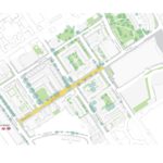
One example where I used these ‘Active Travel Priority’ measures recently was during the Stage 2 design of Olympia Way, situated in London Borough of Hammersmith and Fulham. It is the primary public realm space for the Olympia Masterplan development which has been designed with pedestrians, cyclists and deliveries in mind; whilst also considering the space for use by exhibition and events logistics, and future commercial tenants. During the design of the space, we prioritised clear spatial separation between people and vehicles, reducing the likelihood of clashes and resulting harm. The clear separation is particularly important to create a safe environment for vulnerable users. To achieve this, we proposed the following subtle measures, which could be replicated on future schemes:
- Differences in the colour and texture of paving material for the loading bays, pedestrian only spaces and areas to be shared with vehicles.
- A visually-contrasting flushed kerb to delineate that is made of a darker stone.
- Use of tactile paving at prominent crossing locations, even though all area is levelled, to communicate to drivers where they should be aware of pedestrians crossing.
- Strategically placed telescopic bollards to allow entry of delivery vehicles during the allocated vehicle access hours and when required in emergencies.
- Bespoke paving units at intervals to designate the cycle lane, instead of using conventional white road marking.
In my opinion, the success of a shared space depends on all users being able to use the area “safely” by avoiding confusion. Being able to achieve this “clear but subtle” designation of space to be used by certain types of users is key.